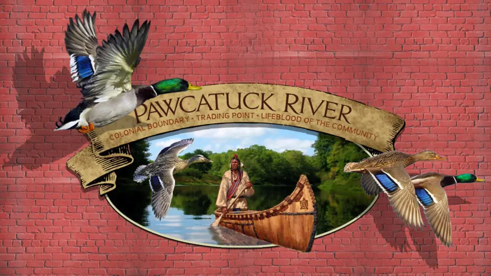
The following is part eight in Westerly Life’s “Behind the Murals” series discussing the history behind all of the recently created murals throughout downtown Westerly. The mural discussed below, which celebrates the history of the Pawcatuck River, can be found on the side of the Walton Block in Pawcatuck, home to Legends Smoke Shop and Modern Barber and Shave, and is visible from Donahue Park.
For centuries, the Pawcatuck River has been pivotal in shaping both Westerly’s physical landscape, as well as its culture. Dutch explorer Adriaen Block (the namesake of Block Island) is believed to have been the first European to travel up the river when he did so during an expedition, c. 1614.[1] Block initially referred to the river as East River, however, the name would later be changed to Pawcatuck.
In 1658, the Massachusetts Bay Colony granted Captain Daniel Gookin land on the eastern side of the Pawcatuck, in what is now Watch Hill. Thus began a conflict spanning three colonies and lasting nearly 100 years.[2]
Every Westerly resident knows that the Pawcatuck River now serves as the border between Rhode Island and Connecticut, however, during the early years of Westerly’s settlement, the river and its status as a boundary line was frequently called into question. In 1657 and 1660, the several wealthier settlers in Providence and Newport combined their funds to make two important purchases from the Native Americans.
The first was the Pettaquamscutt Purchase, which incorporated the towns of Narragansett, South Kingstown, and part of North Kingstown. The second was the Misquamicut Purchase, which included Westerly, and parts of Hopkinton and Charlestown.[3] These purchases were in direct conflict with the claims of the Connecticut Colony, which asserted that its eastern border extended all the way to Narragansett Bay.[4]
Slowly, settlers started to occupy the land between Narragansett Bay and the Pawcatuck River. Soon, not only were claims from Connecticut raising questions about the ownership of this land, but the Massachusetts Bay Colony also attempted to declare a right to the same property.
Between 1661 and 1662, Tobias Saunders and Robert Burdick, two of the settlers on the land who claimed loyalty to Rhode Island, were arrested and brought before the General Court of Massachusetts on charges of trespassing. According to the court, the men were not able to properly justify their actions, and thus were fined £40 and held in prison until the fines were paid.
In the closing of the court’s letter to Rhode Island, they issued a warning saying that:
“unless you command of your inhabitants that yet continue their possessing at Southertowne and Pettascomscott (the land east of the Pawcatuck) [to leave] before the last of June next, you may expect we shall not continue to neglect the reliefe[sic] and protection of our people thus molested, and shall account it our duty to secure all such persons and estates of yours as shall be found within our jurisdiction until all just damages be satisfied.” [sic] [5]
That same year, the State of Rhode Island responded to these claims by stating that those who have settled on the land “have approbation of ye court so to doe…provided they have made fayre[sic] and honest lawful purchase from the native owners thereof.”[6]
The issues between the settlers and the colonial governments of Connecticut and Massachusetts came to a head at a meeting of the Commissioners for the United Colonies of New England on September 4, 1662. During this meeting, Captain Gookins, the man originally granted land east of the Pawcatuck in 1658, and others sent a letter to the government of Massachusetts making several disparaging claims about the Rhode Island settlers.[7]
In this letter, which refers to the land as “the right of Massachusetts at Paucatucke[sic],” the Rhode Island settlers were accused of: acting in pretend authority, building on the land, threatening Captain Gookin’s tenants, carrying said tenant to prison and driving away his cattle, cutting the tenant’s grass, profaning the Sabbath, and selling great quantities of liquor to the Pequots.[8] Lastly, the letter noted that a charter bearing the seal of England was sent to some Connecticut residents granting them land on the east side of the river.
The issue became so volatile that King Charles II of England issued a charter to the State of Rhode Island and Providence Plantations in 1663 which laid out the bounds of the colony, which included the following description:
“bounded on the west, or westerly, to the middle or channel of a river there, commonly called and known by the name of Pawcatuck, alias Pawcatuck river, and soe along the sayd river, as the greater or middle streame[sic] thereof reacheth or lyes vpp into the north countrye, northward, unto the head thereoof, and from thence, by a streight lyne drawn due north, vntill itt meets with the south lyne of the Massachusetts Collonie.” [sic] [9]
Connecticut’s main contention had always been that the wording of original agreements regarding both colonies described the boundary as the ‘Narragansett River’ which was the name initially assigned to the Pawcatuck River. Connecticut settlers and lawmakers took this term to mean Narragansett Bay, and as a result, they felt they held a right to all land extending to the shore of the Bay. For this reason, the 1663 charter included a statement intended to address this confusion, which read:
“the aforesavd Pawcatuck river haven byn yielded, after much debate, for the fixed and certain bounces betweene these our sayd Colonies, by the agents thereof; w hoe have alsoe agreed, that the sayd Pawcatuck river shall bee alsoe called alias Norrogansett or Narrogansett river; and to prevent future disputes, that otherwise might arise thereby, forever hereafter shall bee construed, deemed and taken to bee the Narragansett river in our late Irrupt to Connecticutt.” [sic] [10]
Although it was assumed that a decree from the King of England would settle the matter, in 1664, a royal commission was sent to New England to assess the facts of the disagreement. This commission decided in favor of the Rhode Islanders, giving them right to all land on the eastern shore of the Pawcatuck River.[11]
Still, Connecticut persisted, appealing the decision and filing petitions. Initially, they agreed to terms in 1703, however, Connecticut reneged on the agreement shortly thereafter. A settlement in 1728 ended the border dispute between Westerly and Stonington, setting the Pawcatuck River as the dividing line. It was not until 1746 when the matter was finally put to rest completely, with Connecticut accepting the terms laid out in the Rhode Island Charter of 1663.[12]
[su_accordion class=””] [su_spoiler title=”Footnotes” open=”no” style=”default” icon=”plus” anchor=”” class=””]
[1] “Westerly Observes Its 250th Birthday” Providence Magazine, Volume 31, June 1919, pg. 267.
[2] Burkhardt, Roberta and Joanna M., “A Peninsular Paradise” in Fair Westerly, pg. 31.
[3] McLoughlin, William G., Rhode Island: A History, (New York, NY, 1986), pg. 39-40.
[4] McLoughlin, William G., Rhode Island: A History, (New York, NY, 1986), pg. 39-40.
[5] Records of the Colony of Rhode Island and Providence Plantations, vol. I, pgs. 462-463.
[6] Records of the Colony of Rhode Island and Providence Plantations, vol. I, pgs. 469.
[7] Records of the Colony of Rhode Island and Providence Plantations, vol. I, pgs. 499.
[8] Records of the Colony of Rhode Island and Providence Plantations, vol. I, pgs. 499.
[9] Yale Law School, The Avalon Project, the Rhode Island Charter of 1663, http://avalon.law.yale.edu/17th_century/ri04.asp/.
[10] Yale Law School, The Avalon Project, the Rhode Island Charter of 1663, http://avalon.law.yale.edu/17th_century/ri04.asp/.
[11] McLoughlin, William G., Rhode Island: A History, (New York, NY, 1986), pg. 40.
[12] McLoughlin, William G., Rhode Island: A History, (New York, NY, 1986), pg. 40, 56.
[/su_spoiler] [/su_accordion]